

A global ghost hunt: mapping dead trees with aerial imagery and machine learning
- Kathryn Hand

- Oct 29, 2024
- 4 min read
By Kathryn Hand
When we think of ecology, many of us probably think of scenes of green, growing, living things. But sometimes, the dead can be far more intriguing. As Halloween approaches, let’s shift our focus from the living to the dead and step into the world of tree mortality.
Death is, of course, a natural and essential part of a healthy forest ecosystem – dead trees provide crucial habitats for many species. However, with a changing climate, trees face greater risks from heat and drought stress, which are significant drivers of forest mortality. Changing climates also interact with other causes of mortality, such as enabling the introduction of new pests and diseases, or weakening trees making them susceptible to other threats such as windthrow (Hartmann et al. 2018). An increase in frequency and severity of forest mortality events could undermine the role of forests in helping us address the climate and biodiversity crises we currently face (Hartmann et al. 2022).

The International Tree Mortality Network (ITMN) is tackling the challenge of tree death to better understand it’s patterns and help forests globally. An initiative of the IUFRO’s Task Force on Global Tree Mortality, the ITMN aims to establish a global monitoring network for tree mortality events. They focus on both the “how” (developing effective monitoring methods, particularly using remote sensing tools) and the “why” (understanding the drivers of tree mortality).
The network doesn’t shy away from the complexity of the task on hand. Understanding tree mortality is challenging due to the inter-dependency between climate, species, management and other biotic and abiotic factors (Hartmann et al. 2018). A central focus is to collaborate globally to build representative insights. To achieve this, they maintain a global tree mortality database, linking research from around the world.
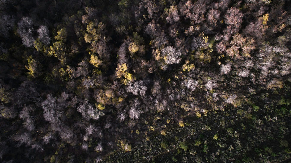
Spatial mapping plays a vital role in this effort. Advances in remote sensing are enabling greater availability and quality of images which can enable identification of dead trees and help identify the cause of death. Prof Dr. Teja Kattenborn and Clemens Mosig are two researchers working on this topic area and recently shared their work with the ITMN in one of their recent seminars. Their project, ‘deadtrees.earth’, is an open database of remotely sensed images of forest mortality events. The platform has an open call to collaborators to get involved by uploading aerial images of forests to help build a global database of tree mortality images, as well as help to train models to identify and assess tree mortality events.
After their seminar, we got a chance to ask them a few questions on their work:
Why should we care about dead trees?
There have always been dead trees. However, in many regions of the globe, we experience more dead trees that we have seen in previous decades. This ‘excess tree mortality’ hints that the ecosystems are experiencing unusual changes. This could be due to climate change, climate extremes, different forest management, invasive pests and pathogens. Thus, understanding these drivers is of uttermost importance to understand the resilience and resistance of our ecosystems but also to project their future pathways.
How good are we at understanding the drivers of tree mortality?
The extent of tree mortality worldwide remains largely unknown or imprecise. There are a lot of local studies on drivers behind tree mortality but, we lack understanding of tree mortality and its drivers at a global scale. Understanding this requires solid data on spatiotemporal dynamics of tree mortality.
What are you trying to achieve with deadtrees.earth?
Before being able to ask why trees die, we need to get a precise overview when and where exactly they die. We try to provide the scientific community with globally and spatially representative data on tree mortality. This we can only do with Earth observation data from satellites. However, to translate the signals from satellites into tree mortality information, we need machine learning. Machine learning in turn requires data for training. Luckily, we have more than a thousand drone images as an example catalog, where we know the exact location of dead trees. The location of the dead trees in the drone images can be automatically derived using artificial intelligence. Thus, we use a two step approach: First, we automatically locate all trees in drone images. Then we use these small areas to train the satellite-based machine learning models which can then reveal dead tree crowns across the entire globe. However, this can only work around the entire globe, if we have drone data distributed around the globe.
Why get involved with deadtrees.earth?
Access to unprecedented drone data collection on forest dynamics. Help us to reveal global mortality patterns. Submission of drone orthophotos for the contributors’ local area helps improve our models for the community in their region. This in turn improves our global precision and understanding and drivers behind tree mortality.

Many thanks to Teja and Clemens for sharing their thoughts. It will be exciting to see how the combination of cutting-edge technology and global collaboration can improve our understanding of tree mortality, and help to enhance the resilience of our forests against the many threats they face. If you’d like to learn more about this project, tree mortality, or just want to look at some dead trees to get into the Halloween spirit, please see the links below!
Visit the deadtrees.earth webpage to check out all available aerial imagery and upload your own!Catch all the details of Teja and Clemens’ work in their recorded seminar, along with others from the ITMN here: Seminars – International tree mortality network (tree-mortality.net).
For more information on the work of Teja and Clemens, check out their recent preprint on the deadtrees.earth project: deadtrees.earth – An Open-Access and Interactive Database for Centimeter-Scale Aerial Imagery to Uncover Global Tree Mortality Dynamics. Available at: https://www.biorxiv.org/content/10.1101/2024.10.18.619094v2


Comments